AC:ToD Pre-Order Bonus Map: Difference between revisions
No edit summary |
No edit summary |
||
| Line 13: | Line 13: | ||
* Throughout the map, a grid is visible. It is especially visible in the area above the words "Northern Osteth". If one inspects the map closely, there are also words visible. The placement of these words and the grid are identical to [http://ac.warcry.com/media/images/maps/derethmap_2006_08_06.png THE Map] available on [http://ac.warcry.com/content/game_info/dereth_maps/ Warcry's Crossroads of Dereth map section]. | * Throughout the map, a grid is visible. It is especially visible in the area above the words "Northern Osteth". If one inspects the map closely, there are also words visible. The placement of these words and the grid are identical to [http://ac.warcry.com/media/images/maps/derethmap_2006_08_06.png THE Map] available on [http://ac.warcry.com/content/game_info/dereth_maps/ Warcry's Crossroads of Dereth map section]. | ||
[[File:ToD Pre-order Map.png]] | [[File:ToD Pre-order Map.png|750px]] | ||
[[Category:Printed Material]] | [[Category:Printed Material]] | ||
Latest revision as of 01:42, 7 February 2018
Related topics: Printed Materials
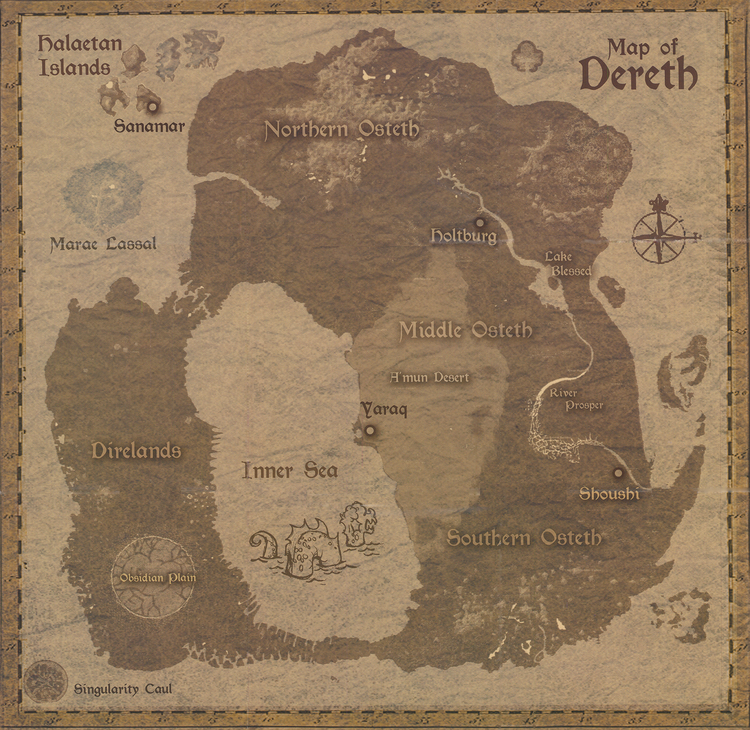
The AC:ToD Pre-Order Bonus Map was one of the exclusive items received for pre-ordering the Throne of Destiny expansion pack. It was advertised on the pre-order packaging as a "detailed Map of Dereth including the new lands", however, the quality of the map is very poor.
Criticisms:
- The map provides very little information. The only towns labeled are Holtburg, Sanamar, Shoushi, and Yaraq - the starting towns. The only geographic areas listed are the A'mun Desert, the Direlands, the Halaetan Islands, Lake Blessed, Marae Lassel (mislabeled Marae Lassal), Middle Osteth, Northern Osteth, the Obsidian Plains (mislabeled Obsidian Plain), River Prosper, Singularity Caul, and Southern Osteth.
- While the mainland and other surrounding islands are clearly made from the actual digital map of Dereth from the game files, the Halaetan Isles are not - instead they appear to be either artist rendered or created from an out-of-date version of the islands which never appeared to the public.
- Marae Lassel is barely visible when compared to the other land masses.
- The image has had effects added to it that make most of the terrain very low detailed. In addition, the map is one color, lessening in terrain detail it could have had.
- An effect was applied to the A'mun Desert to give it an even look. This effect was poorly applied, and one can see the edge of the effect and the coast of the Inner Sea do not match up.
- The map is edged with a numbered scale border. However these scale marks and numbers do not match up with the actual coordinate system.
- Throughout the map, a grid is visible. It is especially visible in the area above the words "Northern Osteth". If one inspects the map closely, there are also words visible. The placement of these words and the grid are identical to THE Map available on Warcry's Crossroads of Dereth map section.
