Northern Landbridge: Difference between revisions
No edit summary |
>Arkalor's Bot m (Text replace - "Category:Geographic Area" to "Category:Geographic Areas") |
||
| Line 1: | Line 1: | ||
[[ | {{Intro | ||
== | | Patch Introduced = [[Release]] | ||
The area of land at approximately 15.2N, 50.7W that connects the | | Related Quests = | ||
| Updated = | |||
}} | |||
{|align=right | |||
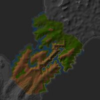
|[[File:Northern Landbridge.jpg|thumb|300px|Northern Landbridge]] | |||
|- | |||
|align=center|__TOC__ | |||
|} | |||
=== Description === | |||
The area of land at approximately 15.2N, 50.7W that connects the [[North Direlands]] to [[Northern Osteth]]. | |||
== | === Related [[Quests]] === | ||
* [[Plateau Village Transit]] | |||
* | |||
=== Route === | |||
* The quickest route is via the [[Lesser Direlands Device]] at your [[Mansion]]. | |||
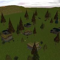
* You can also take the [[Last-Stop-Before-Dires Villas]] Portal outside [[Plateau Village]] at 45.4N, 42.3W. It drops you right at the eastern end of the land bridge. | |||
* If available for summoning, there is a [[Direlands North Landbridge Portal]] inside the [[Direlands Subway]] (lockpick required). | |||
=== [[Points of Interest]] === | |||
{|border=0 cellpadding=3 | |||
| | |||
* [[13.0N, 53.7W - Fallen Advocate Tower]] | |||
| | |||
* [[15.6N, 49.9W - Tumerok Tower]] | |||
| | |||
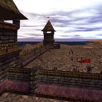
* [[16.5N, 50.5W - Tumerok Fortification]] | |||
| | |||
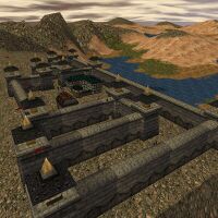
* [[Castle Pietrus|19.4N, 49.5W - Castle Pietrus]] | |||
|- | |||
| | |||
* [[10.2N 56.4W - Empyrean Ruins]] | |||
| | |||
|} | |||
=== [[Housing Settlements]] === | |||
{|border=0 cellpadding=3 | |||
| | |||
* [[Ridge Route Mansion|16.3N, 43.0W - Ridge Route Mansion]] | |||
| | |||
* [[19.8N, 53.3W - Cottage]] | |||
| | |||
* [[Peril's Edge Cottages|23.3N, 49.6W - Peril's Edge Cottages]] | |||
| | |||
* [[Dire's Edge|23.1N 54.2W - Dire's Edge Cottages]] | |||
|} | |||
=== [[Lifestone]]s === | |||
* [[10.2N 56.4W - Empyrean Ruins|10.2N, 56.4W]] | |||
=== [[Dungeons]] === | |||
{{Dungeon Table | |||
| Table Rows = | |||
{{Dungeon Maps | |||
| Dungeon = Mountain Halls | |||
| Coordinates = 10.1N 56.7W | |||
| Wiki Map File = | |||
| ACmaps ID = 0192 | |||
}} | |||
{{Dungeon Maps | |||
| Dungeon = Mount Naipenset Caverns | |||
| Coordinates = 5.6N, 56.2W | |||
| Wiki Map File = | |||
| ACmaps ID = 0147 | |||
}} | |||
{{Dungeon Maps | |||
| Dungeon = Tumerok Mine | |||
| Coordinates = 7.9N, 61.3W | |||
| Wiki Map File = | |||
| ACmaps ID = 01C1 | |||
}} | |||
}} | |||
== | === [[Creatures]] === | ||
Note: Most landscape creatures have a spawn map on the creature's article page. | |||
{{Creature Class|Banderling | |||
| Location = Landscape | |||
| Banderling Mangler | |||
}} | |||
{{Creature Class|Undead | |||
| Location = Landscape | |||
| Revenant | |||
}} | |||
{{Creature Class|Skeleton | |||
| Location = Landscape | |||
| Great Skeleton | |||
| Skeletal Hero | |||
| Skeleton Bone Knight | |||
| Skeleton Bone Lord | |||
}} | |||
{{Creature Class|Tumerok | |||
| Location = Landscape | |||
| Ascendant Tumerok | |||
| Augmented Tumerok | |||
| Tumerok High Priest | |||
| Tumerok Taskmaster | |||
| Tumerok Trooper | |||
}} | |||
{{Creature Class|Tusker | |||
| Location = Landscape | |||
| Rampager | |||
}} | |||
== | === Images === | ||
<gallery widths=200px heights=200px perrow=4> | |||
File:Northern Landbridge.jpg|Northern Landbridge | |||
File:Last-Stop-Before-Dires Villas Live.jpg|Last-Stop-Before-Dires Villas | |||
File:Castle Pietrus Live.jpg|Castle Pietrus | |||
File:16.5N, 50.5W - Tumerok Fortification Live.jpg|Bloodstone Company Fortress | |||
</gallery> | |||
[[Category:Geographic Areas]] | |||
[[Category:Geographic | |||
Latest revision as of 15:06, 12 April 2014
| Introduced: | Release |
 |
Description Edit
The area of land at approximately 15.2N, 50.7W that connects the North Direlands to Northern Osteth.
Related Quests Edit
Route Edit
- The quickest route is via the Lesser Direlands Device at your Mansion.
- You can also take the Last-Stop-Before-Dires Villas Portal outside Plateau Village at 45.4N, 42.3W. It drops you right at the eastern end of the land bridge.
- If available for summoning, there is a Direlands North Landbridge Portal inside the Direlands Subway (lockpick required).
Points of Interest Edit
Housing Settlements Edit
Lifestones Edit
Dungeons Edit
| Dungeon | Coordinates | Wiki Map | ACmaps |
|---|---|---|---|
| Mountain Halls | 10.1N 56.7W | -- | 0192 |
| Mount Naipenset Caverns | 5.6N, 56.2W | -- | 0147 |
| Tumerok Mine | 7.9N, 61.3W | -- | 01C1 |
Creatures Edit
Note: Most landscape creatures have a spawn map on the creature's article page.
Images Edit
-
Northern Landbridge
-
Last-Stop-Before-Dires Villas
-
Castle Pietrus
-
Bloodstone Company Fortress


